Tag: wave clouds

  • Wave Clouds in the Atacama

    Wave Clouds in the Atacama

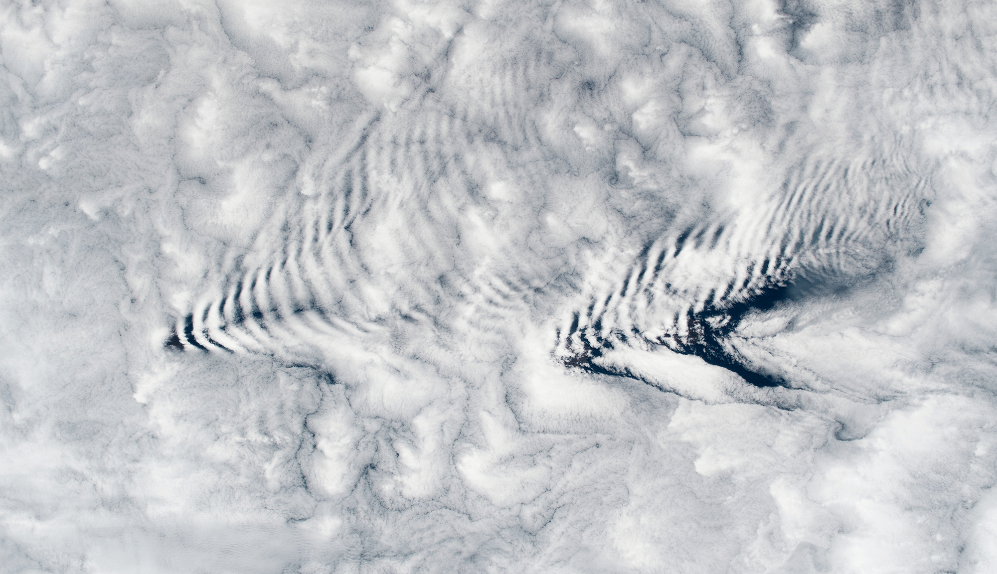
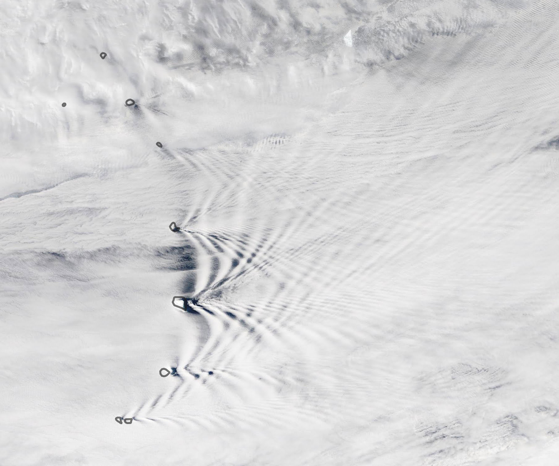
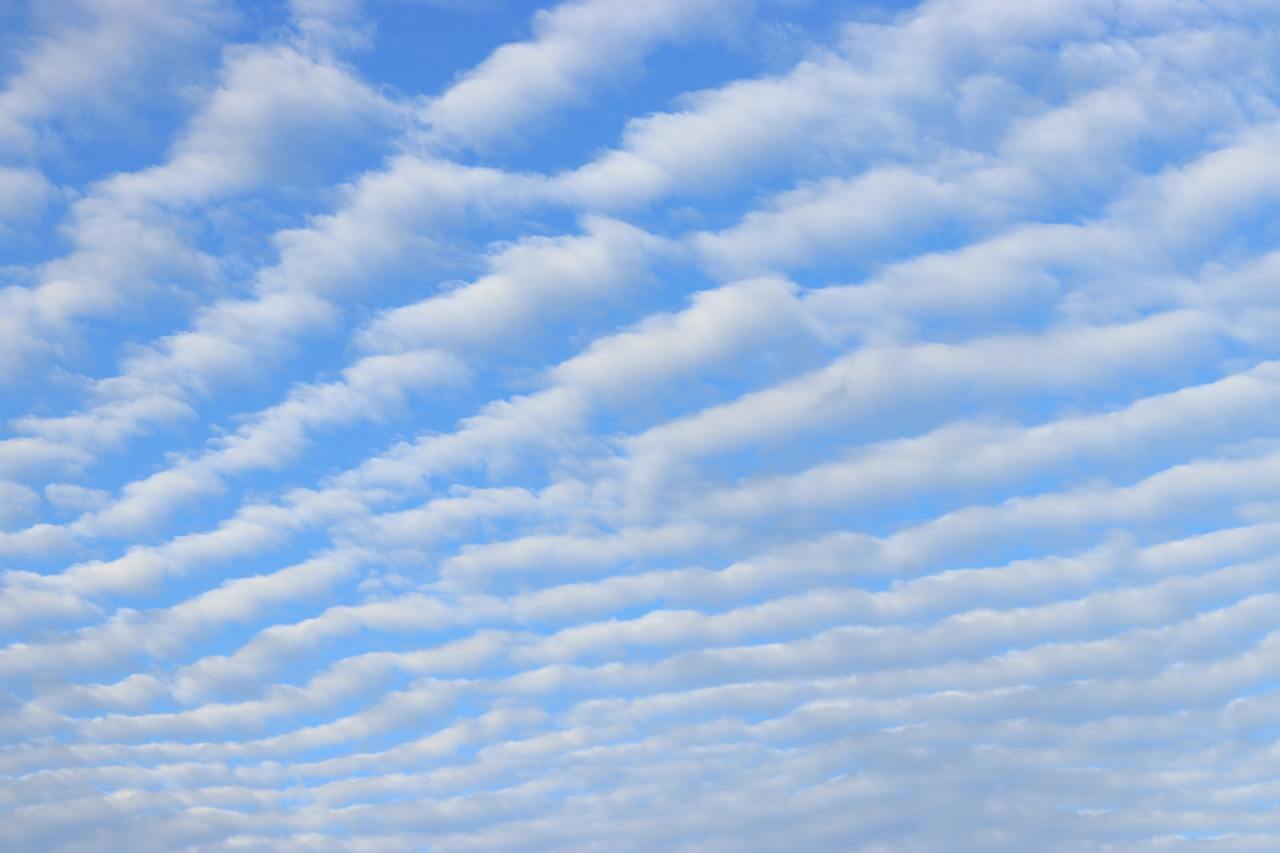
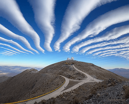
    Striped clouds appear to converge over a mountaintop in this photo, but that’s an illusion. In reality, these clouds are parallel and periodic; it’s only the camera’s wide-angle lens that makes them appear to converge.

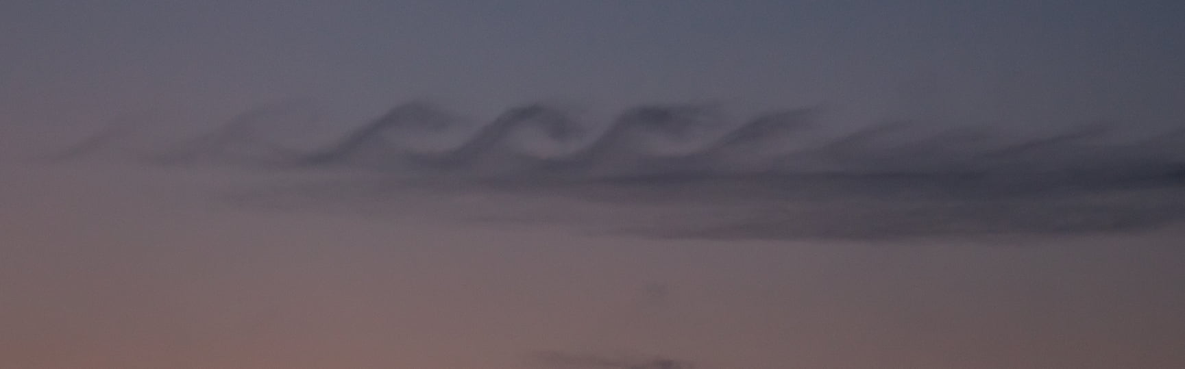
    Wave clouds like these form when air gets pushed up and over topography, triggering an up-and-down oscillation (known as an internal wave) in the atmosphere. At the peak of the wave, cool moist air condenses water vapor into droplets that form clouds. As the air bobs back down and warms, the clouds evaporate, leaving behind a series of stripes. You can learn more about the physics behind these clouds here and here. (Image credit: Y. Beletsky; via APOD)

    Fediverse Reactions
  • Wave Clouds From Space

    Wave Clouds From Space

    An astronaut snapped this image of wave clouds formed around the Crozet Islands, which lie between South Africa and Antarctica. Clouds like these form when warm, moist air gets pushed up and over a mountain. As it rises, the air cools and its pressure decreases, causing condensation. Pushed out of equilibrium, gravity then pulls the air back downward in the wake of the mountain. That warms the air, causing evaporation. Like a mass bouncing on a spring, the air continues to yo-yo up and down, forming cloudy stripes and clear ones until the energy from its mountain climb is spent. (Image credit: NASA; via NASA Earth Observatory)

  • Colorful Kelvin-Helmholtz Clouds

    Colorful Kelvin-Helmholtz Clouds

    Like breaking waves at the beach, these wavy clouds curl but only for a moment. The photo was captured near sunset on a late August evening in Arlington, MA. This short-lived cloud shape forms due to the Kelvin-Helmholtz instability, which is driven by shear forces between two layers of air moving at different speeds. The situation is a common one in the atmosphere, where air layers at altitude move in different directions and at different speeds. Most of the time we cannot see the curls that form between these air layers because of air’s transparency. But occasionally the mismatch happens right at a cloud layer and the condensation of the cloud gets pulled into these distinctive curls. (Image credit: B. Bray; submitted by Mark S.)

  • Featured Video Play Icon

    A Year From Geostationary Orbit

    Our planet is a complex fluid dynamical system, and one of the best ways to watch nature at work is through timelapse. This short film takes us through an entire year, from December 2015 to December 2016, as viewed from a geostationary weather satellite centered over Oceania.

    The imagery is rather hypnotic, with clouds swirling day and night across the full field of view. Watch closely, though, and you’ll see a lot of neat phenomena from typhoons forming in the Pacific to wave clouds streaming from the islands of Japan. You can also see clouds blossoming (especially during the day) over the humid rainforests of Oceania.

    There are neat non-fluids phenomena, too, like a total solar eclipse and the permanent sunlight of Arctic and Antarctic summers. What do you notice? (Image and video credit: F. Dierich)

  • Crisscrossing Wave Clouds

    Crisscrossing Wave Clouds

    Crisscrossing lines of wave clouds mark the wake of the Sandwich Islands in this satellite image. The tallest islands in the chain thrust rocky peaks more than 1000 meters above sea level, disrupting winds flowing across the ocean. Incoming air is forced up and over the mountain, which puts it at odds with the surrounding air at that height.

    Due to differences in temperature and density, the disrupted air will continue to rise and sink periodically as it flows onward. At some heights it will cool enough to condense its water vapor into clouds, and at others, it will warm enough to lose any cloud cover. This is what creates the bands of clouds we see behind each individual island. (Image credit: L. Dauphin/NASA; via NASA Earth Observatory)

  • Wave Clouds in the Front Range

    Wave Clouds in the Front Range

    Last Sunday night metro Denver was treated to a rare sight: clouds resembling breaking waves formed near sunset. These are Kelvin-Helmholtz clouds, and the comparison to ocean waves is apt, since the same physics is behind both. Winds were unusually calm near the ground Sunday night, but strong winds blew at the altitude just above the lower cloud layer. That velocity difference created strong shear where the two air layers met. With the cloud layer in place to differentiate the slower-moving air from the faster, we can what’s normally invisible: how the two air layers mix.

    The Denver Post has several more views of the wave clouds from around the area, and you can learn lots more about the Kelvin-Helmholtz instability here. (Image credit: R. Fields; via the Denver Post)

  • Striped Clouds

    Striped Clouds

    Living near the Rocky Mountains, it’s not unusual to look up and find the sky striped with lines of clouds. Such wave clouds are often formed on the lee side of mountains and other topography. But even in the flattest plains, you can find clouds like these at times. That’s because the internal waves necessary to create the clouds can be generated by weather fronts, too.

    Imagine a bit of atmosphere sitting between a low-pressure zone and a high-pressure zone. This will be an area of convergence, where winds flow inward and squeeze the fluid parcel in one direction before turning 90 degrees and stretching it in the perpendicular direction. The result is a sharpening of any temperature gradient along the interface. This is the weather front that moves in and causes massive and sudden shifts in temperature. 

    On one side of the front, warm air rises. Then, as it loses heat and cools, it sinks down the cold side of the front. The sharper the temperature differences become, the stronger this circulation gets. If the air is vertically displaced quickly enough, it will spontaneously generate waves in the atmosphere. With the right moisture conditions, those waves create visible clouds at their crests, as seen here. For more on the process, check out this article over at Physics Today. (Image credit: W. Velasquez; via Physics Today)

  • Wave Clouds

    Wave Clouds

    Stripe-like wave clouds can often form downstream of mountains. This satellite image shows such clouds in the South Pacific where rocky mountains jut 600 meters (2,000 ft) above the sea. This disrupts air flowing east by forcing it to move up and over the island topography. The air does not simply settle back down on the other side, though. It must come back into equilibrium with its surroundings in terms of density and temperature. While doing so it will travel up and down along a wavy path. As it reaches the crest of the wave, humid air cooling condenses and forms a cloud. At troughs, the air warms and the condensation disappears. This creates the stripey cloud pattern in the mountain’s wake, which fades out as the atmospheric gravity waves die out. (Image credit: NASA/J. Schmaltz; via NASA Earth Observatory)

  • Lincolnshire KH Clouds

    Lincolnshire KH Clouds

    These beautiful Kelvin-Helmholtz clouds were spotted over Lincolnshire on December 19th. They form between two layers of air, one of which is moving faster than the other. Although that situation is not very unusual, the conditions have to be just right for visible clouds to form at that interface between layers, and the clouds themselves are typically short-lived. This set is particularly lovely with its smooth curves and breaking wave form. If you, like me, love these clouds but never manage to see them yourself, you can always try wearing some instead! (Image credit: A. Towriss; via BBC News; submitted by Vince D.)

  • Breaking Waves in the Sky

    Breaking Waves in the Sky

    Under the right atmospheric conditions, clouds can form in a distinctive but short-lived breaking wave pattern known as a Kelvin-Helmholtz cloud. The animation above shows the formation and breakdown of such a cloud over the course of 9 minutes early one morning in Colorado’s Front Range region. Kelvin-Helmholtz instabilities occur when fluid layers with different velocities and/or densities move past one another. Friction between the two layers moving past creates shear and causes the curling rolls seen above.

    In the background, you can also see a foehn wall cloud low to the horizon. This type of cloud forms downwind of the Rocky Mountains after warm, moist Chinook winds are forced up over the mountains, cool, and then condense and sink in the mountains’ wake. (Image credit and submission: J. Straccia, more info)