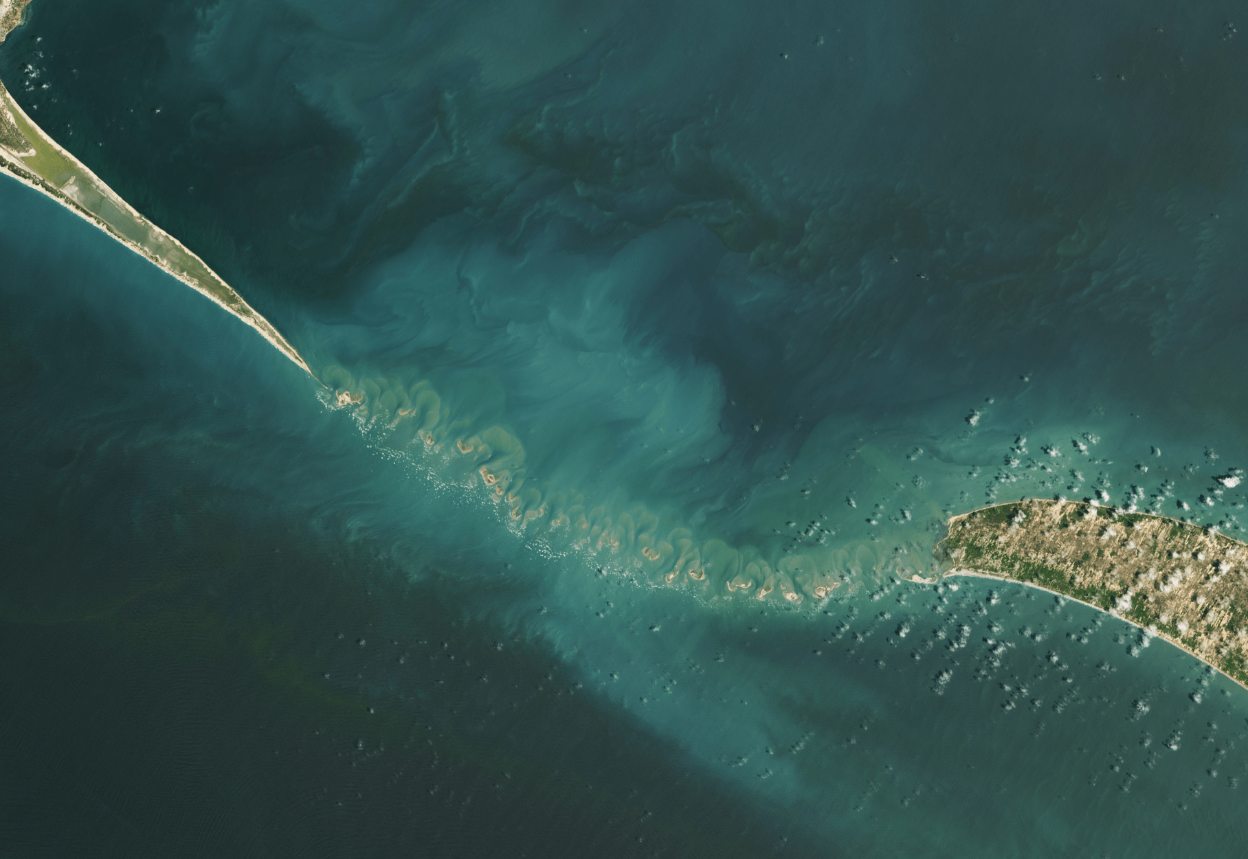
Pale plumes of sediment flow off these islands in the Gulf of Mannar between India and Sri Lanka. As waves erode the land, currents and tides carry the sediment outward, shaping it into swirls and eddies. I rarely tire of satellite images like these because there are always subtle new details of flow to notice. The photos are much like paintings, with layer after layer to decipher the closer you look. (Image credit: A. Nussbaum; via NASA Earth Observatory)
Tag: sediment transport

Stirring Up Sediment
In early February, Tropical Cyclone Gabrielle passed over the Bellona Plateau in the Coral Sea, stirring up sediment from the shallow reefs there. Once the storm cleared, large swirls of carbonate sediment mixed into the deeper waters around the plateau. As the sediment sinks to depths of kilometers, it will dissolve into the deep ocean waters, eventually getting captured as part of sedimentary rocks. This is a critical step in the ocean’s carbon capture cycle.
Unfortunately, climate change is disrupting the ocean’s ability to capture carbon. An excess of carbon dioxide acidifies ocean waters, making it harder for creatures like corals and crabs to incorporate carbon into their bodies. That reduces sources for carbonate sediments like those seen here. Changes in ocean chemistry also affect where and how much carbonate can get dissolved. In short, ocean carbon capture has been an important process for Earth’s carbon cycle in the past, but the process is a slow one, and human activity has overloaded the ocean’s system in ways we don’t fully understand. (Image credit: A. Nussbaum; via NASA Earth Observatory)

Why We Can’t Control Rivers


Rivers are systems in a constant state of change, balancing flow speeds, path length, sediment deposition, and erosion, as seen in this previous Practical Engineering video. The next video in this mini-series considers what human interventions do to rivers. As convenient as it is for humanity to force a river into a straight and constant course, the long-term effects can be incredibly destructive both upstream and downstream.
In this video, Grady takes a look at several types of interventions: stream straightening, dams, river crossings, and more. With the help of a stream table, he demonstrates just how these efforts shift the river’s balance and what effects — in terms of erosion, deposition, and flooding — each can cause. These disadvantages, along with habitat destruction, are part of why stream remediation projects are on the rise. (Video and image credit: Practical Engineering)
Why Rivers Shift


In their natural state, rivers are variable in their course, shifting and meandering. Sometimes they deposit sediment, and sometimes they erode it. In this video, Grady from Practical Engineering digs into the principles behind these changes. With help from Emriver‘s stream tables, which demonstrate years of changes in a river over minutes, Grady shows how changing the sediment load, flow rate, and other factors in a river affect its course. (Video credit: Practical Engineering)

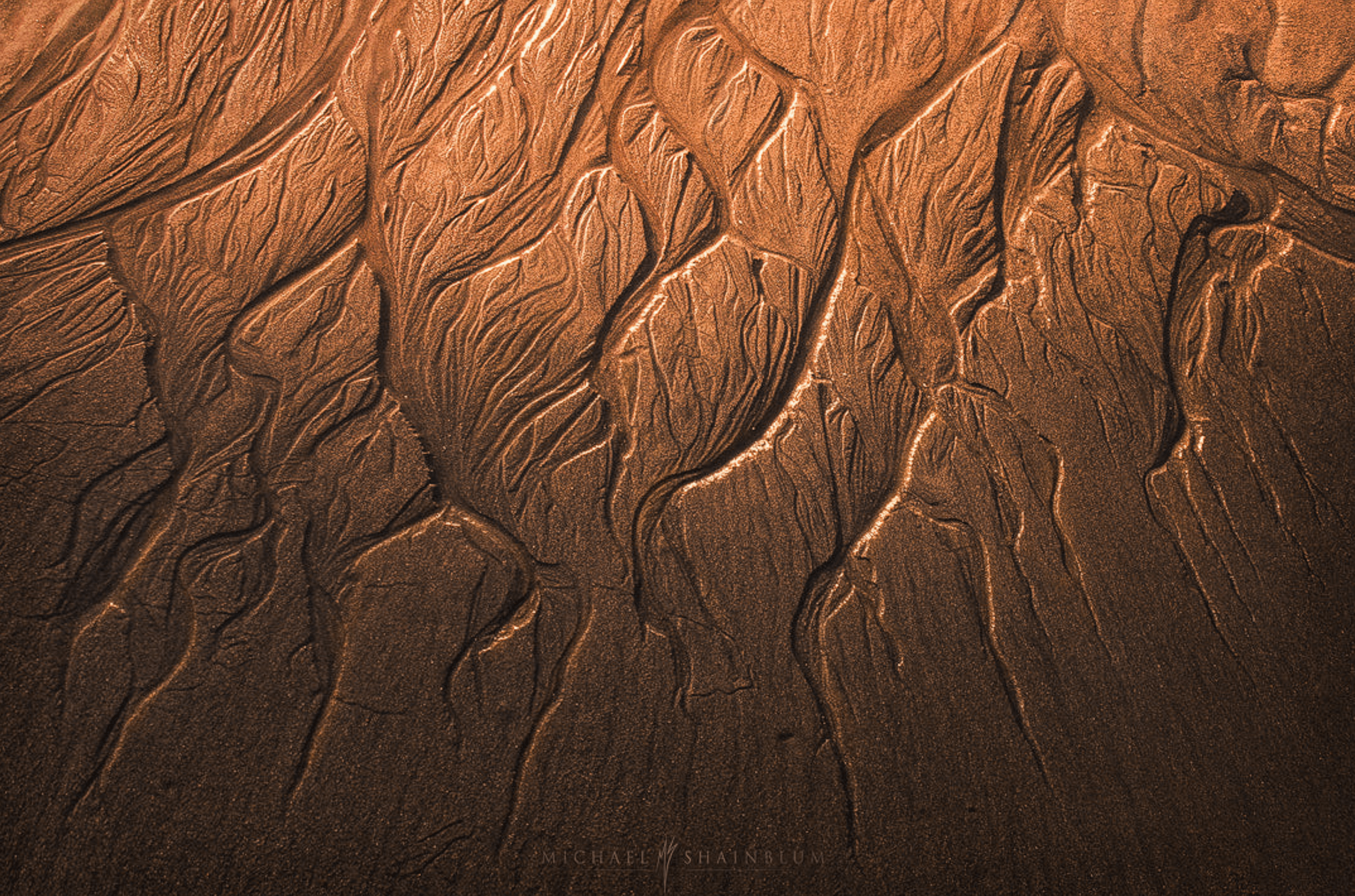
“Ruin of the Tides”
As tides and waves flow back and forth over a beach, they erode the sandy shore. Here photographer Michael Shainblum captures the streaks and rivulets left by a falling tide. These “ruins” resemble an extensive river delta viewed from above. I love the complicated branches carved by the water’s retreat. (Image credit: M. Shainblum)
How Sewers Work


One of the most important and underappreciated pieces of urban infrastructure is the sewage system. We rely on them to make our waste vanish, as if by magic. In reality, these systems are carefully engineered and built to be largely self-cleaning and future-proof. Gravity is the primary driver of the system, and engineers design the slope of sewage lines so that flow inside the pipes is fast enough to keep solid waste suspended. There are, of course, plenty of challenges involved; check out the full video for an overview. (Image and video credit: Practical Engineering)

Ingenuity’s Dust Cloud


Mars is quite dusty. It periodically gets swallowed by planet-spanning dust storms, but it’s also home to regular dust devils whose size can put Earth’s to shame. Exactly how so much dust gets picked up by Mars’ incredibly thin atmosphere — only 1% of Earth’s — is still something of a mystery. So scientists were excited after the Ingenuity helicopter’s fourth flight, where cameras on the Perseverance rover caught a billowing dust cloud following Ingenuity as it flew. Knowing how the helicopter flies, they may be able to unravel just how its wake picks up and carries dust. Since Ingenuity’s only purpose was to demonstrate flight on another planet, this would be a big scientific bonus for an already successful mission! (Image credit: NASA/JPL-Caltech/ASU/MSSS/SSI; via Nature; submitted by Kam-Yung Soh and jpshoer)

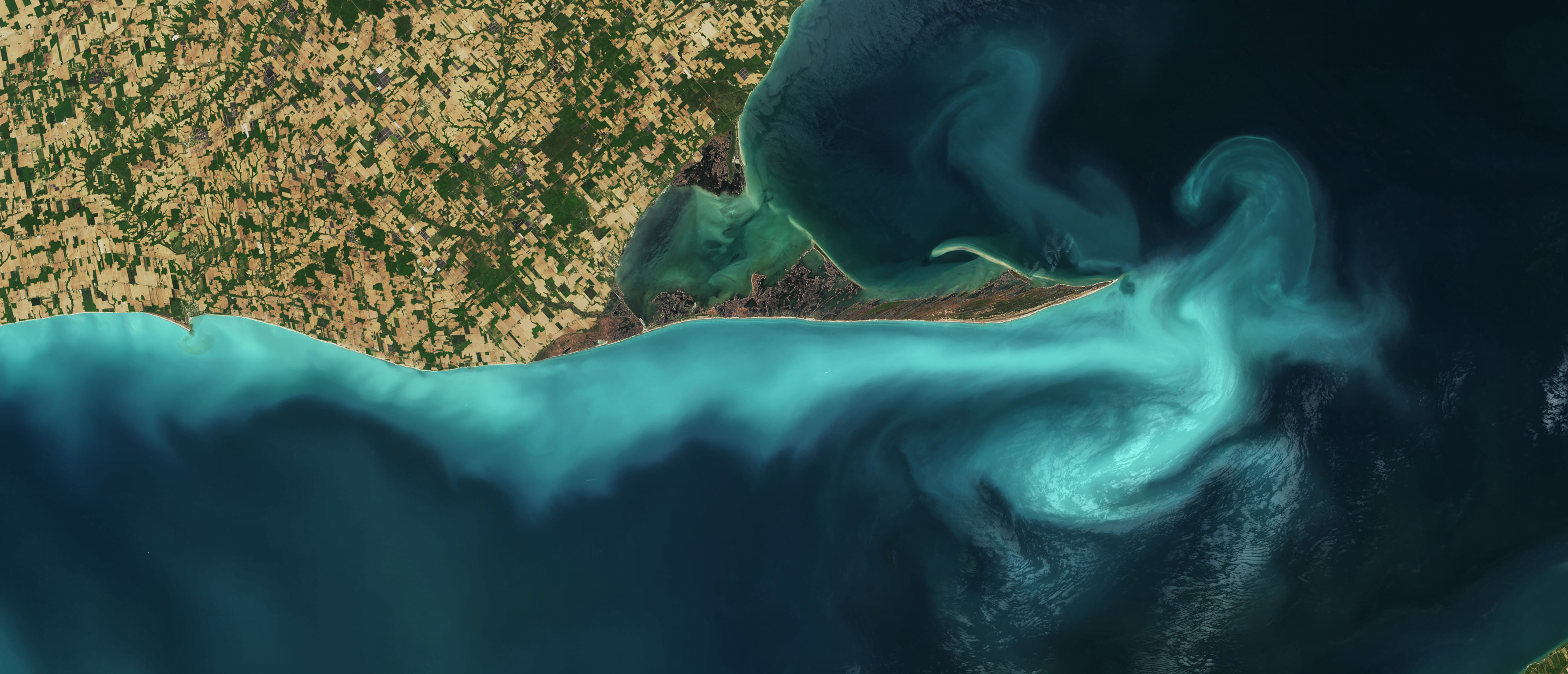
Suspended Sediments in Lake Erie
Lake Erie’s Long Point is outlined in turquoise in this natural-color satellite image. The pale color is likely due to limestone sediments in the shallow waters getting resuspended by a seiche or other disturbance. A seiche is a standing wave that forms in a partially- or fully-bounded body of water; in Lake Erie they are typically wind- and weather-driven. (Image credit: J. Stevens/USGS; via NASA Earth Observatory)

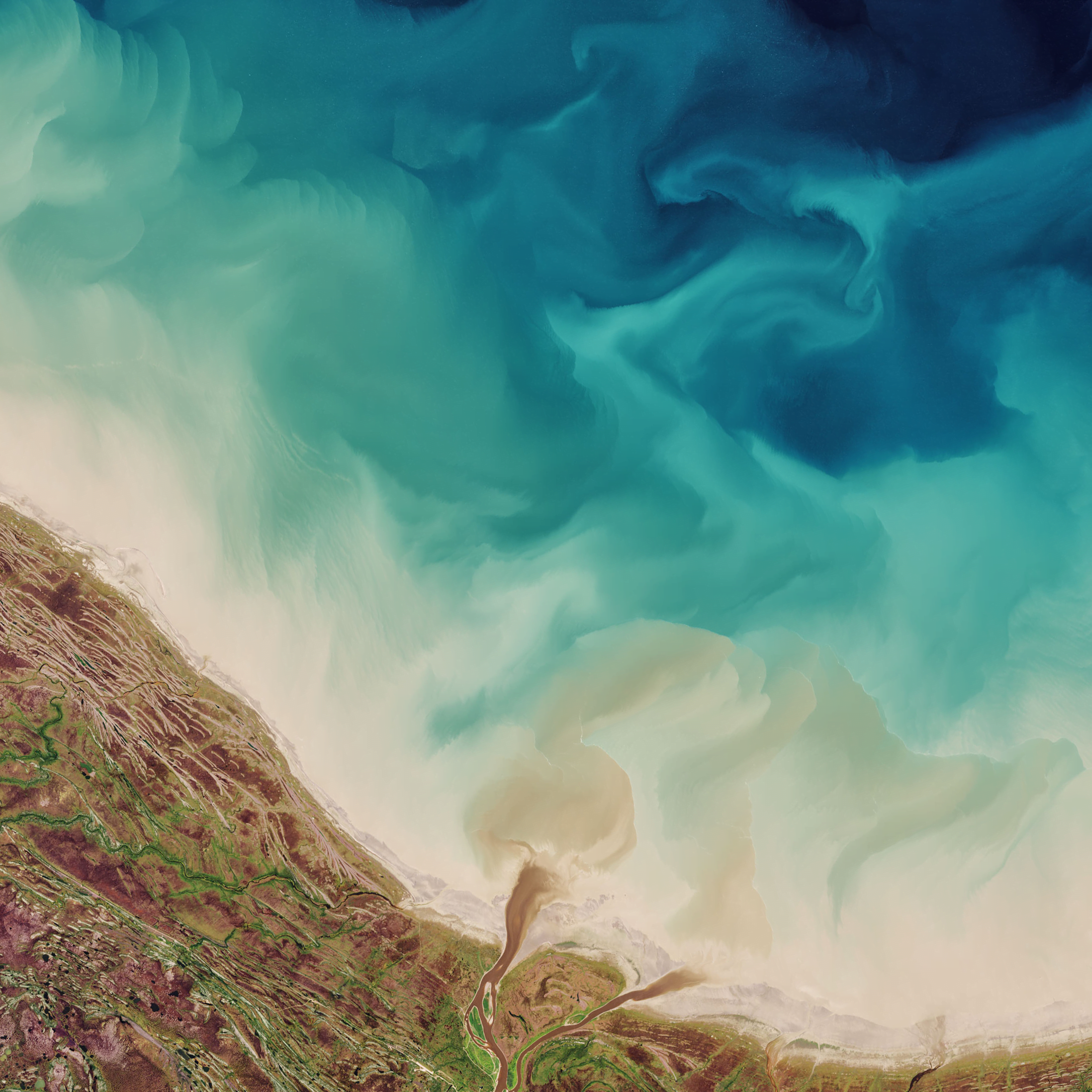
Hudson Bay Watercolors
Rivers sweep fresh water and sediment into the Hudson Bay in this satellite image. Dark brown plumes mark the mouths of several coastal rivers as they add to the cyclonic sediment flow around the bay and out the Hudson Strait. Paler swirls, like strokes of watercolors, mark turbulent mixing between the sediment-filled shallows and the deep blue waters of the bay. (Image credit: J. Stevens/USGS; via NASA Earth Observatory)
Making a Miniature River


Despite wide differences in ecology and geology, rivers around the world share certain fundamental features. Physicists study these characteristics by creating small-scale rivers in the laboratory, like the experiment featured in this Lutetium Project video. Within these systems, scientists can carefully control variables and discover useful patterns, like the two parameters needed to describe the shape of a river’s profile! (Image and video credit: The Lutetium Project)