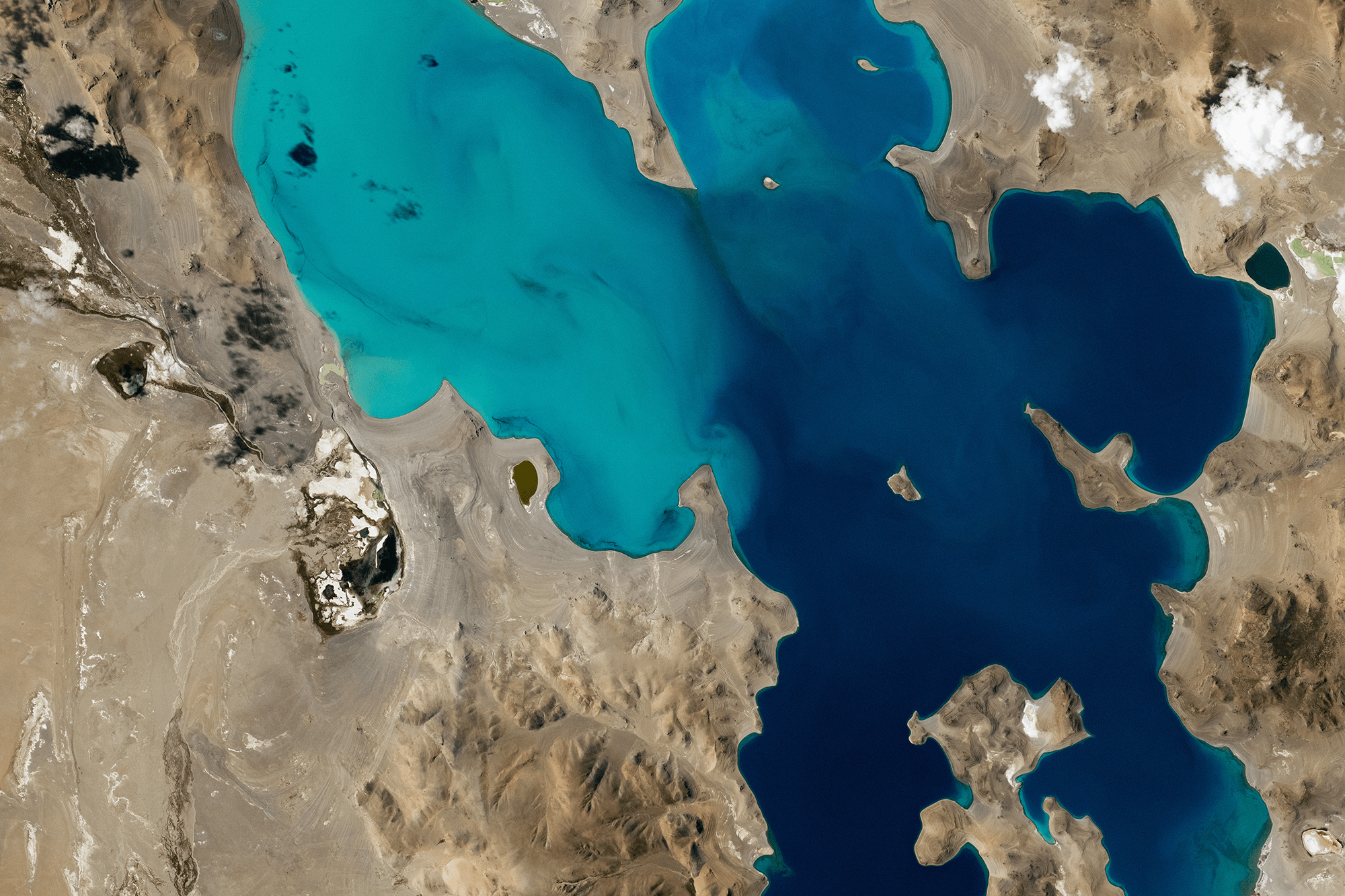
Ngangla Ringco sits atop the Tibetan Plateau, breaking up the barren landscape with eye-catching teal and blue. This saline lake sits at an altitude of 4,700 meters, fed by rainfall, Himalayan runoff, and melting glaciers and permafrost. The lake, like many inland bodies of salt water, has no outflow. Instead, water evaporates from the lake, leaving behind any salts that were dissolved in it. Over time, those left-behind salts build up and make the lake ever saltier. (Image credit: NASA; via NASA Earth Observatory)
Tag: astronaut

A Sprite From Orbit
A sprite, also known as a red sprite, is an upper-atmospheric electrical discharge sometimes seen from thunderstorms. Unlike lightning, sprites discharge upward from the storm toward the ionosphere. This particular one was captured by an astronaut aboard the International Space Station. That’s a pretty incredible feat because sprites typically only last a millisecond or so. The first one wasn’t photographed until 1989. (Image credit: NASA; via P. Byrne)
Fediverse Reactions
-

Glacial Tributaries
Just as rivers have tributaries that feed their flow, small glaciers can flow as tributaries into larger ones. This astronaut photo shows Siachen Glacier and four of its tributaries coming together and continuing to flow from the top to the bottom of the image. The dark parallel lines running through the glaciers are moraines, where rocks and debris are carried along by the ice. Those seen here are medial moraines left by the joining of tributaries. When glaciers retreat, moraines are often left behind, strewn with sediment that ranges from the fine powder of glacial flour all the way to enormous boulders. (Image credit: NASA; via NASA Earth Observatory)
Fediverse Reactions
-

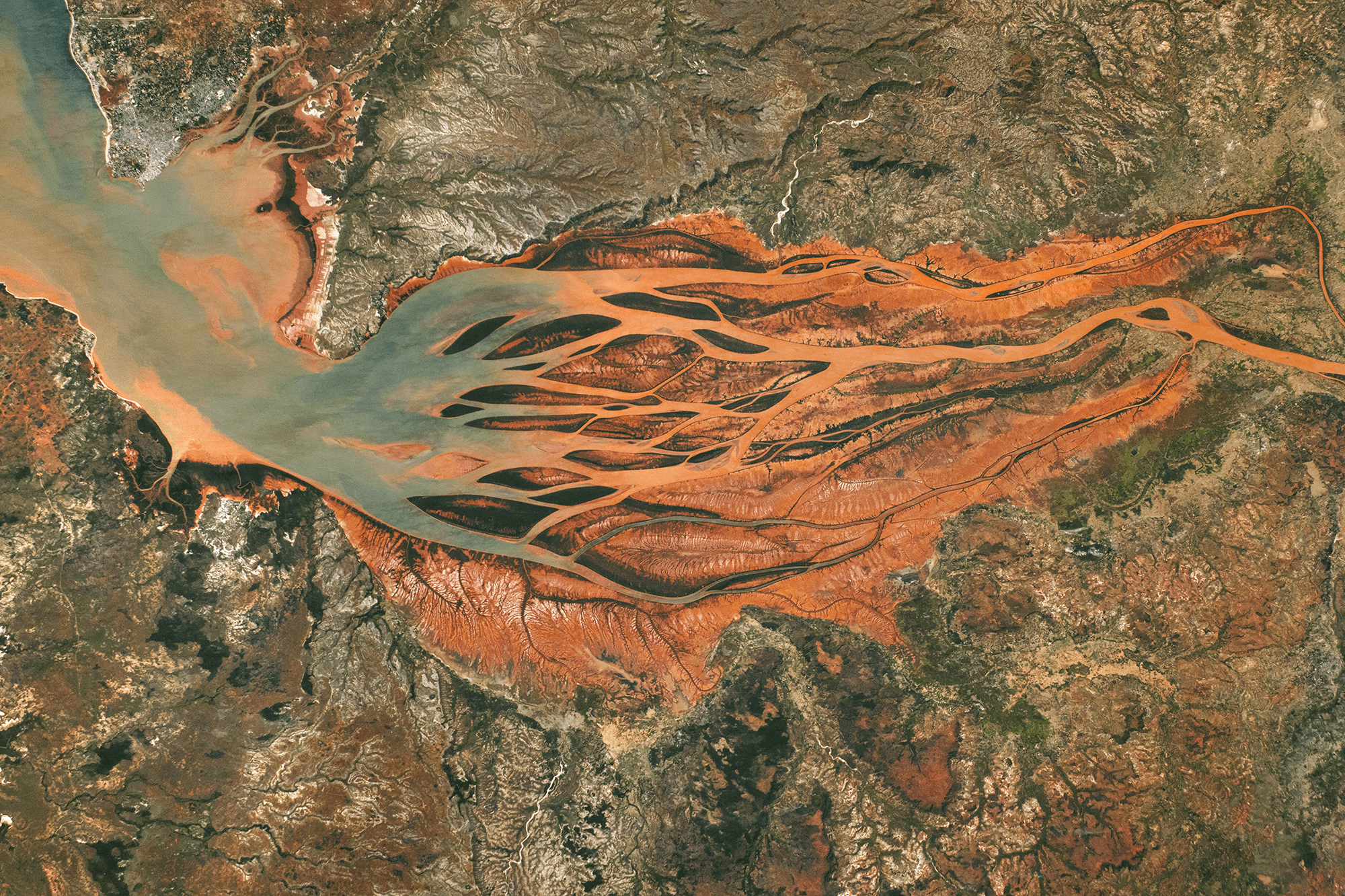
Growing Downstream
This astronaut photo shows Madagascar’s largest estuary, as of 2024. On the right side, the Betsiboka River flows northwest (right to left, in the image). Less than 100 years ago, most of the estuary was navigable by ships, but now more than half of it is taken up by the river delta. Upstream on the river, extensive logging and expansions to farmland have caused severe soil erosion; the river carries that sediment downstream, dyeing the waters reddish-orange. As the river branches and the flow slows, that sediment falls out of suspension, building up islands and seeding new sand bars further downstream.

A difference of 40 years. A 2024 astronaut photo of the Betsiboka River delta compared with one from 1984 (inset). Several islands are labeled in both images. Notice how new islands have formed upstream of the ones seen in 1984. In the image above, you can compare the 2024 delta to the way it looked in 1984. Letters A, B, C, and D mark the downstream-most islands from 1984. Today newer islands and sand bars sit even further downstream. (Image credit: NASA; via NASA Earth Observatory)
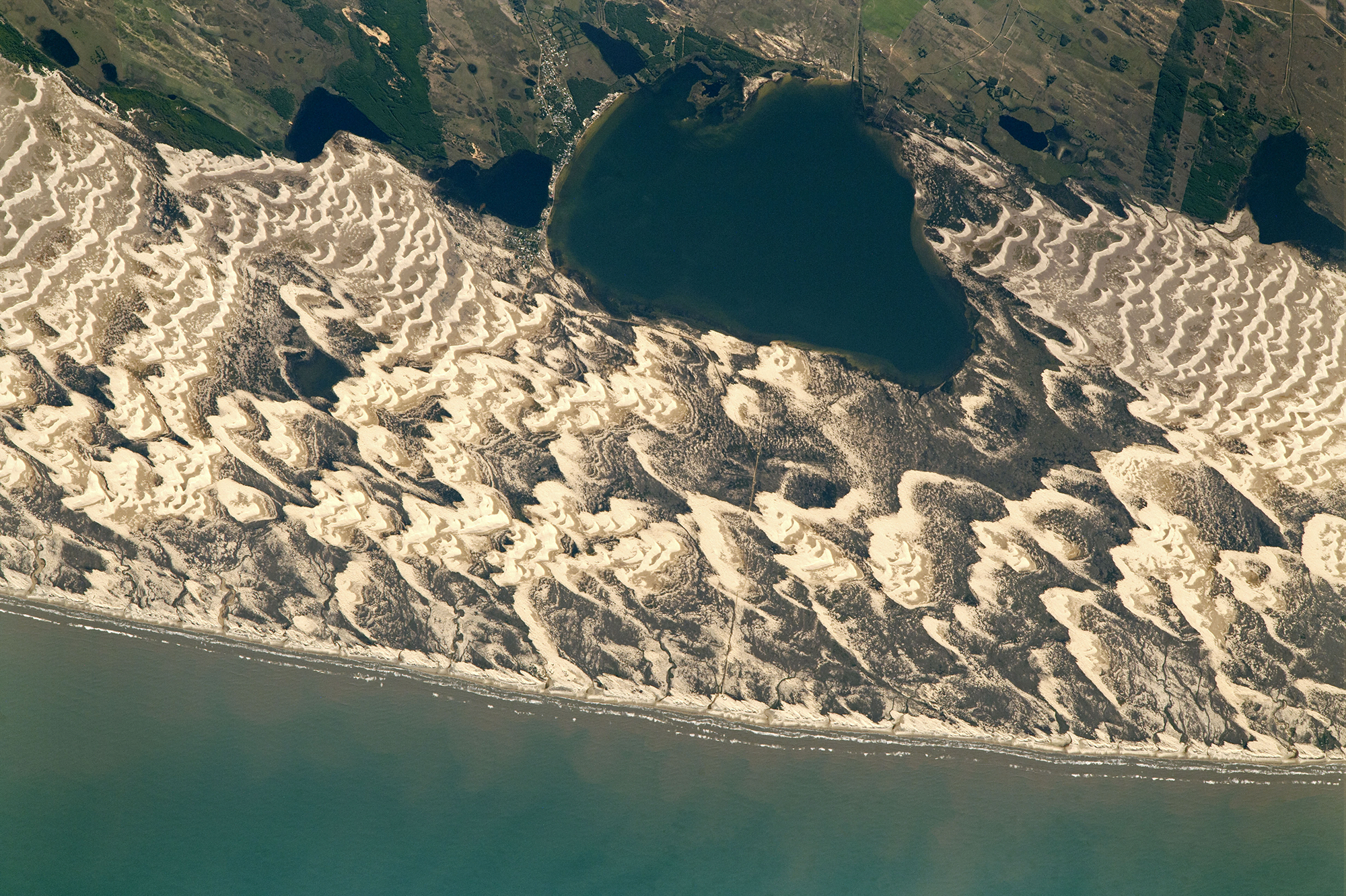
Lines of Ice Eddies
In February 2024, the North Atlantic’s sea ice reached its furthest extent of the season, limning the coastline with tens of kilometers of ice. These images — both capturing the Labrador coast on the same day — show the swirling patterns marking the wispy edges of ice field. In this region, the ice is likely following an eddy in the ocean below. Eddies like these can form along the edges where warm and cold currents meet. An ice eddy is particularly special, though, as the water must be warm enough to fragment the sea ice, but not so warm that it melts the smaller ice pieces. (Image credit: top – NASA, lower – M. Garrison; via NASA Earth Observatory)

This satellite image shows sea ice off the Labrador coast, on the same day in February 2024. 
Ice Without Gravity
Astronaut Don Pettit is back in space, and that means lots of awesome microgravity experiments. Here, he grew thin wafers of ice in microgravity in a -95 degree Celsius freezer. Then he took the ice wafers and photographed them between crossed polarizers, creating this colorful image. The colors highlight different crystal orientations within the ice and give us a hint about how the freezing front formed and expanded. I can’t wait to see more examples! (Image credit: D. Pettit/NASA; via Ars Technica; submitted by J. Shoer)
Fediverse Reactions
-
Langebaan Lagoon
Strands of green and brown mix in Langebaan Lagoon on the South African coast in this astronaut photograph. The shallow tidal estuary has a sandy floor and, since no river flows into it, the deeper green sections seen here are channels carved solely by the back-and-forth flow of the tides. To the north of the lagoon, Saldanha Bay is a busy hub for fishing and industry. The long reddish line extending into the water is a railroad pier responsible for loading 96 percent of South Africa’s iron ore gets loaded onto ships. (Image credit: NASA; via NASA Earth Observatory)

Field of Dunes
Barchan dunes collide in this astronaut image of Brazil’s southern coastline. Barchan (pronounced “bar-kahn”) dunes are crescent-shaped; their tips point downwind into their direction of travel. When many barchan dunes overlap, they coalesce into a dune field like the one seen here. A dune’s speed depends on many factors, including the wind speed, dune size, and its proximity to other dunes. In experiments, dunes have even chased one another and changed speeds to avoid collision. (Image credit: NASA; via NASA Earth Observatory)
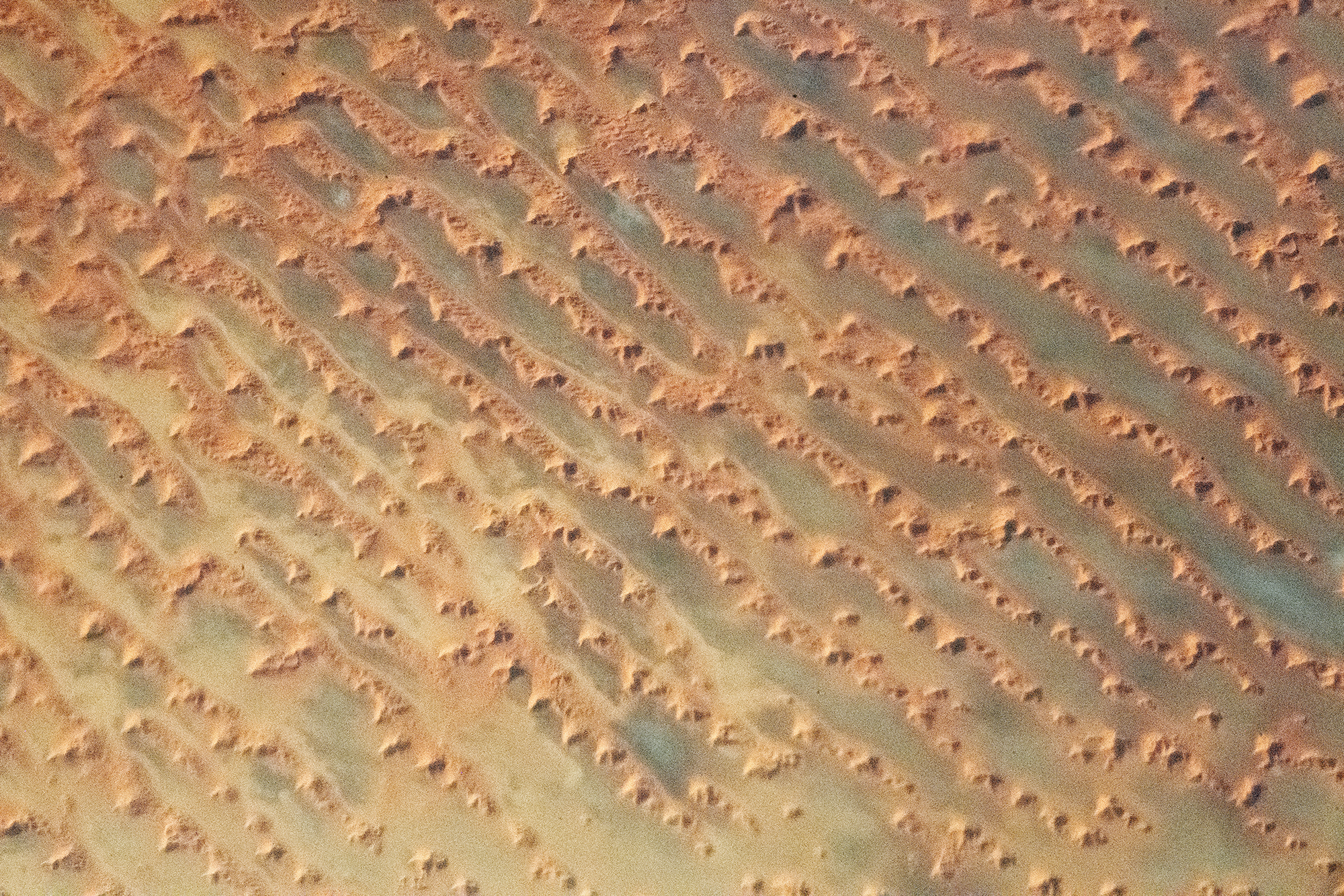
Complex Dunes
Sometimes landscapes have a beauty that’s hard to see from the ground. This astronaut’s photo shows a dune field in the sand seas of Saudi Arabia. Vast linear dunes line up along the direction of prevailing winds. Atop these dunes are more complex formations, star dunes, that are built up in the wake of changing winds. Built from three or more intersecting arms, the star dunes are steeper than the linear dunes they sit atop. Such complex dune fields — with multiple types of dunes — form in areas with especially abundant sands. (Image credit: NASA; via NASA Earth Observatory)

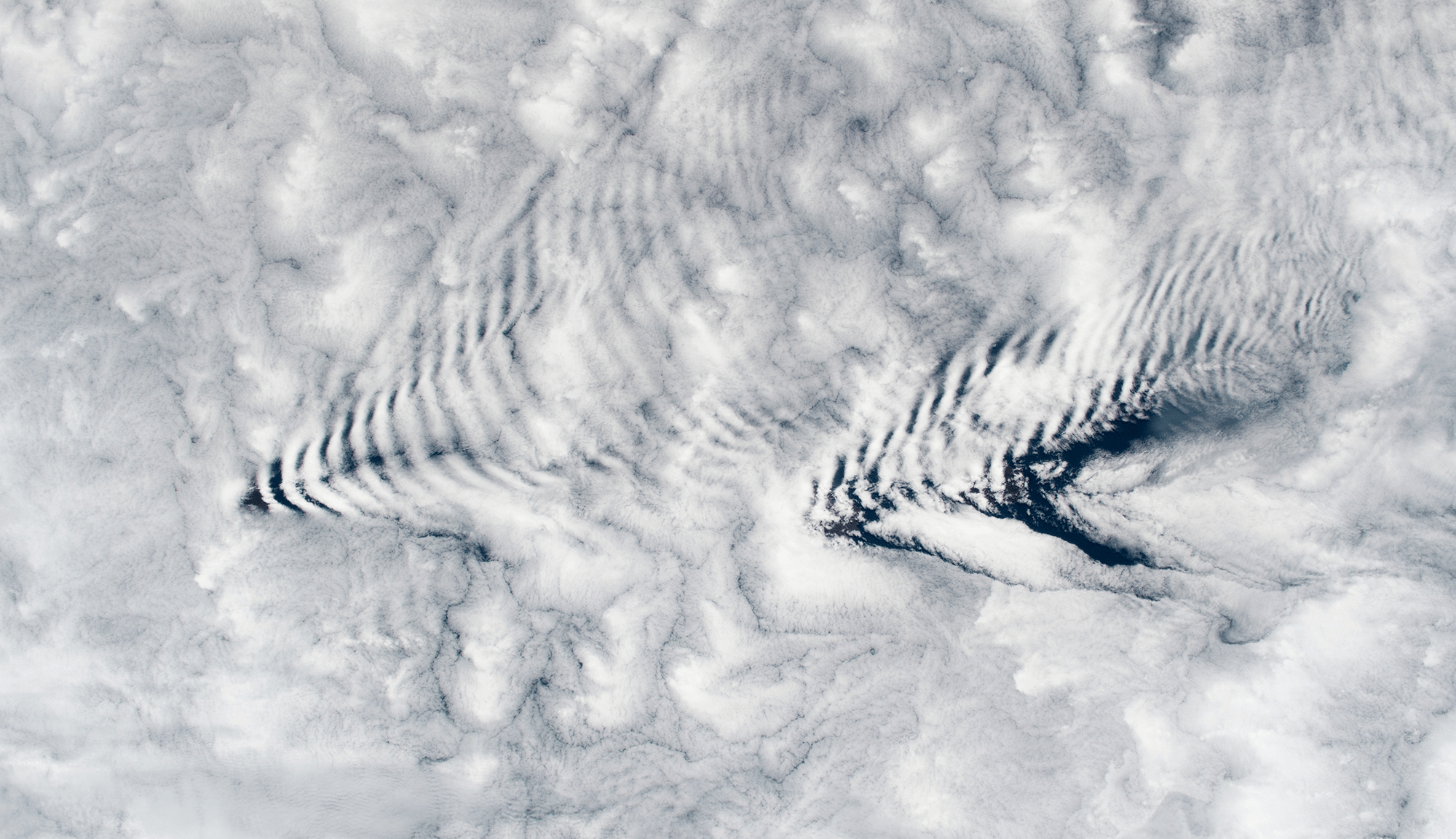
Wave Clouds From Space
An astronaut snapped this image of wave clouds formed around the Crozet Islands, which lie between South Africa and Antarctica. Clouds like these form when warm, moist air gets pushed up and over a mountain. As it rises, the air cools and its pressure decreases, causing condensation. Pushed out of equilibrium, gravity then pulls the air back downward in the wake of the mountain. That warms the air, causing evaporation. Like a mass bouncing on a spring, the air continues to yo-yo up and down, forming cloudy stripes and clear ones until the energy from its mountain climb is spent. (Image credit: NASA; via NASA Earth Observatory)