Tag: seismology

  • Slipping Ice Streams

    Slipping Ice Streams

    The Northeast Greenland Ice Stream provides about 12% of the island’s annual ice discharge, and so far, models cannot accurately capture just how quickly the ice moves. Researchers deployed a fiber-optic cable into a borehole and set explosive charges on the ice to capture images of its interior through seismology. But in the process, they measured seismic events that didn’t correspond to the team’s charges.

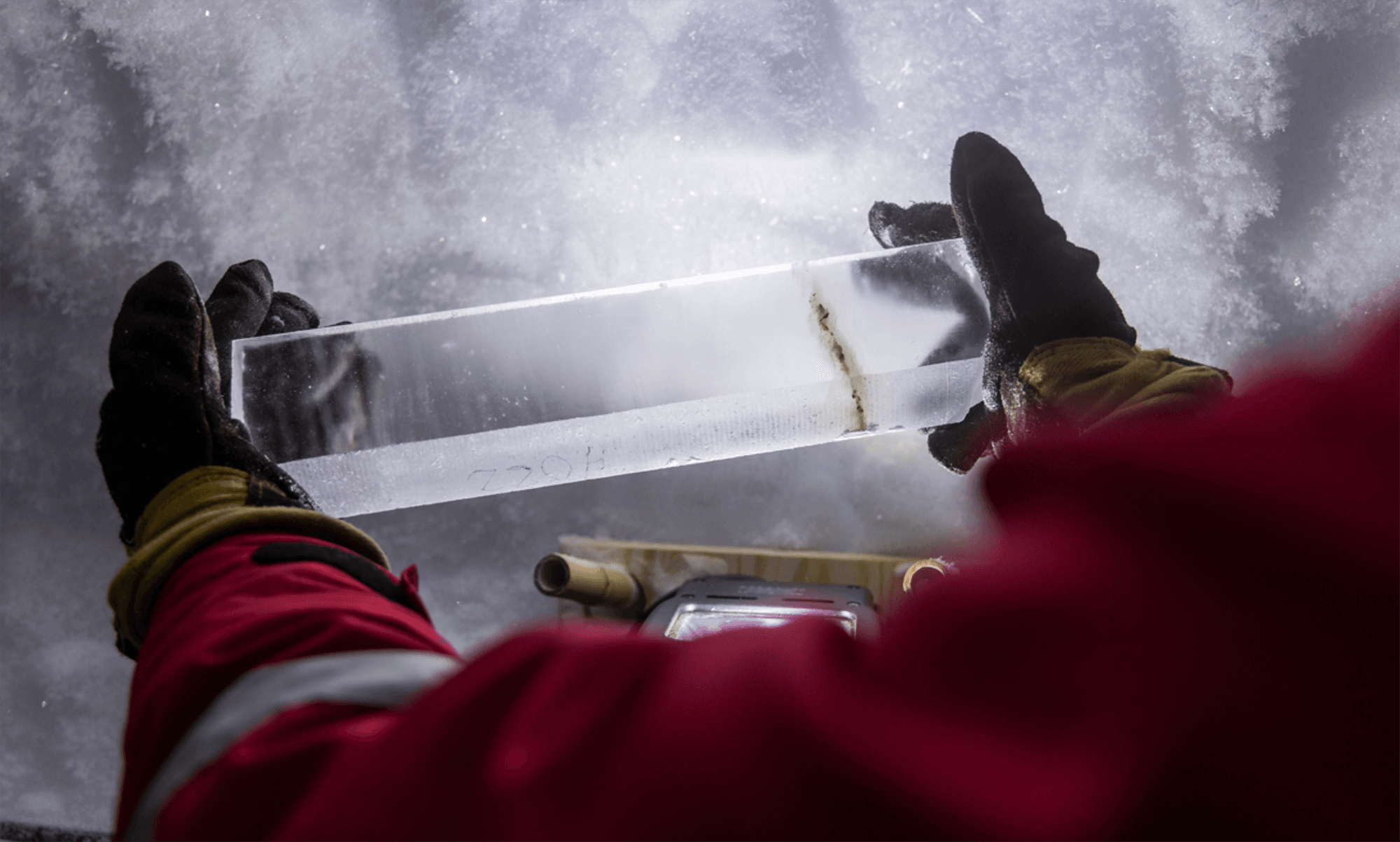
    Instead, the researchers identified the signals as small, cascading icequakes that were undetectable from the surface. The quakes were signs of ice locally sticking and slipping — a failure mode that current models don’t capture. Moreover, the team was able to isolate each event to distinct layers of the ice, all of which corresponded to ice strata affected by volcanic ash (note the dark streak in the ice core image above). Whenever a volcanic eruption spread ash on the ice, it created a weaker layer. Even after hundreds more meters of ice have formed atop these weaker layers, the ice still breaks first in those layers, which may account for the ice stream’s higher-than-predicted flow. (Image credit: L. Warzecha/LWimages; research credit: A. Fichtner et al.; via Eos)

    Fediverse Reactions
  • A Seismic Warning for the Tongan Eruption

    A Seismic Warning for the Tongan Eruption

    In mid-January 2022, the Hunga Tonga-Hunga Ha’apai (HTHH) volcano had one of the most massive eruptions ever recorded, destroying an island, generating a tsunami, and blanketing Tonga in ash. Volcanologists are accustomed to monitoring nearby seismic equipment for signs of an imminent eruption, but researchers found that the HTHH eruption generated a surface-level seismic wave picked up by detectors 750 kilometers away about 15 minutes before the eruption began. They propose that the seismic wave occurred when the oceanic crust beneath the caldera fractured. That fracture could have allowed seawater and magma to mix above the volcano’s subsurface magma chamber, creating the explosive trigger for the eruption. Their finding suggests that real-time monitoring for these distant signals could provide valuable early warning of future eruptions. (Image credit: NASA Earth Observatory; research credit: T. Horiuchi et al.; via Gizmodo and AGU News)

    Fediverse Reactions
  • Reimagining Mars’ Interior

    Reimagining Mars’ Interior

    Older models of Mars assumed a liquid metal core beneath a solid mantle of silicates, but recent studies indicate that structure is missing at least one layer. Using data from the InSight lander’s seismometer, two teams independently calculated that a liquid silicate layer must surround the planet’s core. In September 2021, three meteorite pieces impacted Mars far from the InSight lander’s position. Since the Mars Reconnaissance Orbiter could exactly pinpoint the impact location, researchers were able to calculate just how long it took seismic waves from the impact to reach the lander.

    Like on Earth, Mars has two varieties of seismic wave: transverse S-waves that only travel through solids and longitudinal P-waves that travel through both liquid and solid layers. S-waves reflect off any liquid-solid boundary, following a different path to a seismometer than P-waves that refract across the boundary and travel through liquid. For more of the story behind this discovery, check out this article at Physics Today. (Image credit: Mars – NASA/JPL-Caltech/University of Arizona, illustration – J. Sieben/J. Keisling; research credit: H. Samuel et al. and A. Khan et al.; via Physics Today)

    An illustration of Mars' interior and the paths followed by seismic waves before InSight picked them up.
    An illustration of Mars’ interior and the paths followed by seismic waves before InSight picked them up.
  • Featured Video Play Icon

    Studying Earth’s Interior

    The Earth’s interior is almost entirely inaccessible to humanity, so how do we know what it consists of? As explained in this video, our knowledge of the planet’s interior is based on measuring waves sent out by earthquakes and nuclear blasts. Both produce two kinds of waves — pressure waves (P-waves) and shear waves (S-waves) that travel through the earth and get picked up by seismometers. Scientists noticed that pressure waves travel through the center of the planet while shear waves — which get dissipated in liquids — do not. This led them to conclude that part of Earth’s interior is a liquid. The idea of a solid inner core came from observations of pressure waves scattering in a way that only made sense if they’d hit something solid. (Video and image credit: Science)

  • Hawaiian Magma Complex

    Hawaiian Magma Complex

    Few volcanoes are as well-studied as those of the Big Island of Hawai’i. With a host of seismic monitors and frequent eruptions, scientists know the near-surface region of Hawai’i well. But a recent study looked at nearly 200,000 seismic events after the 2018 collapse of Kilauea’s crater and found hints of what goes on much deeper.

    Mapping out earthquakes beneath the island revealed a cluster of activity near a village named Pahala. These earthquakes took place 36 to 43 kilometers below the surface and seem to be connected to magma filling a sill complex there. From that deep reservoir, the team was also able to map seismic activity leading upwards to both Kilauea and Mauna Loa volcanoes. Despite the 34 kilometers between those two volcanoes, they appear to be fed through the same web of magma! (Image credit: top – USGS, illustration – J. Wilding et al.; research credit: J. Wilding et al.; via Physics Today)

    This cartoon illustrates the web of magma linking Kilauea and Mauna Loa deep underground.
    This cartoon illustrates the web of magma linking Kilauea and Mauna Loa deep underground.
  • Rocking From The Waves

    Rocking From The Waves

    Not all seismic activity stems from earthquakes. In fact, much of Earth’s measured seismic waves come from interactions of the ocean and atmosphere with solid ground. Some of the strongest vibrations come from interactions of ocean waves, which transmit pressure waves that don’t attenuate with depth before passing into the solid Earth.

    How those waves propagate and scatter inside the Earth has been a matter of contention for decades, but recent simulations are beginning to uncover the mechanisms that lead to the waves seismologists measure. (Image credit: I. Mingazova; via Physics Today)

  • Featured Video Play Icon

    Seismic Events Reveal Ocean Temperatures

    Decades ago, researchers proposed sending sound waves through the ocean to measure its temperature. Although the technique worked, it ran into noise pollution issues, but now it’s back, using naturally-occurring seismic events as the sound source.

    When fault lines shift, they generate seismic waves that travel through the ocean as sound. When they reach a land mass, the waves get converted back into seismic energy that’s then picked up by a receiver. Knowing the distance from the source to the receiver and the time necessary for the wave to travel, scientists can then determine the average temperature of the water based on the speed of sound.

    The technique can track temperature changes down to thousandths of a degree. Based on more than a decade of seismic data from the Indian Ocean, researchers found almost double the temperature increase measured by a different sensor network. (Image and video credit: Science; research credit: W. Wu et al.; submitted by Kam-Yung Soh)