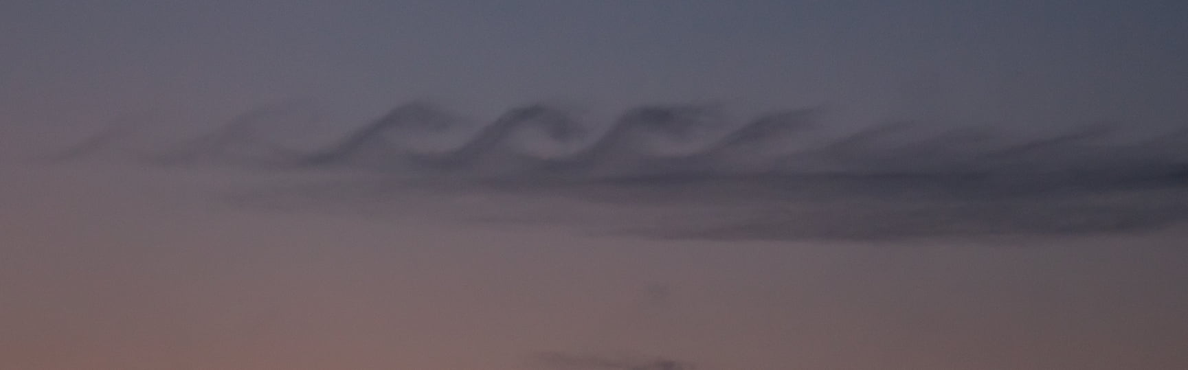
Tag: Kelvin-Helmholtz instability

  • Brace For Impact

    Brace For Impact

    What happens in the moment before an object hits the water? That’s the question at the heart of a new study exploring how water deforms before an object’s impact. The researchers dropped circular disks onto a pool of water and, using a new reflection-based technique, measured micron-sized deflections in the water’s surface before impact, as seen below.

    Animation showing the deflection of the water's surface just before a circular disk impacts it.
    Movie of the water surface’s deflection as the circular disk approaches. Look for distortions in the grid pattern.

    The deflections are caused by the air getting squeezed out of the space between the oncoming object and the water surface. The team found that the deformation isn’t uniform. The air squeezing out along the edges moves fast enough to trigger a Kelvin-Helmholtz instability and actually pull up the water surface. So when the disk hits, it impacts along its edges first and traps an air bubble underneath. (Image credits: divers – E. Carter, experiment – U. Jain et al.; research credit and submission: U. Jain et al.)

  • Jovian Auroras

    Jovian Auroras

    Like Earth, Jupiter is home to polar auroras that light the sky as charged particles interact with the planet’s magnetosphere. A recent paper identifies interesting features in the aurora that appear similar to expanding vortex rings (see inset below). Although the researchers cannot yet identify the origin of the rings, they hypothesize that the process begins at the far edges of Jupiter’s magnetosphere where it interacts with the incoming solar wind. One theory posits that shear flows and Kelvin-Helmholtz instabilities where the magnetosphere and solar wind meet drive the phenomenon. (Image credit: Jupiter – NASA, ESA, and J. Nichols, aurora features – NASA/SWRI/JPL-Caltech/SwRI/V. Hue/G. R. Gladstone/B. Bonfond; research credit: V. Hue et al.; via Gizmodo)

    Diagram showing an inset of Jupiter's northern aurora, with further insets showing the expanding ring features.
  • Featured Video Play Icon

    Protecting From Storm Surge

    The most dangerous and destructive part of a tropical cyclone isn’t the wind or rain; it’s the storm surge of water moving inland. This landward shift of ocean takes place because of a cyclone’s strong winds, which drive the water via shear. The depth storm surges reach depends on the wind speed and direction, shape of the shoreline, and many other factors, making exact predictions difficult.

    Fortunately, engineers can — with enough foresight and investment — build structures and networks to help protect developed land from storm surge flooding. (Image and video credit: Practical Engineering)

  • Sunset Swirls

    Sunset Swirls

    This gorgeous photograph of Kelvin-Helmholtz clouds was taken in late December in Slovenia by Gregor Riačevič. The wave-like shape of the Kelvin-Helmholtz instability comes from shear between two fluid layers moving at different relative speeds. Here on Earth, clouds like these are often short-lived, but we see similar structures in the atmospheres of gas giants like Jupiter and Saturn. (Image credit: G. Riačevič; submitted by Matevz D.)

  • Colorful Kelvin-Helmholtz Clouds

    Colorful Kelvin-Helmholtz Clouds

    Like breaking waves at the beach, these wavy clouds curl but only for a moment. The photo was captured near sunset on a late August evening in Arlington, MA. This short-lived cloud shape forms due to the Kelvin-Helmholtz instability, which is driven by shear forces between two layers of air moving at different speeds. The situation is a common one in the atmosphere, where air layers at altitude move in different directions and at different speeds. Most of the time we cannot see the curls that form between these air layers because of air’s transparency. But occasionally the mismatch happens right at a cloud layer and the condensation of the cloud gets pulled into these distinctive curls. (Image credit: B. Bray; submitted by Mark S.)

  • A Lenticular Cloud With a Curl

    A Lenticular Cloud With a Curl

    Lens-shaped lenticular clouds are not terribly rare in mountainous areas, but observers at Mount Washington caught a very unusual cloud near sunrise in late February. This lenticular cloud had an added curl on top thanks to the Kelvin-Helmholtz instability!

    Lenticular clouds form when air is forced to flow up over a mountain in such a way that its temperature and pressure drop and water vapor in the air condenses. The resulting water droplets form a cloud that appears stationary over the mountain, even though the air continues to flow.

    To get that added wave-like curl, there needs to be another, faster-moving layer of air just above the cloud. As that air flows past, it shears the cloud layer, causing the interface to curl. Neither of these cloud types is long-lived — Kelvin-Helmholtz formations often last only a few minutes — so catching such a great dual example is lucky, indeed! (Image credit: Mount Washington Observatory; via Smithsonian Magazine; submitted by Kam-Yung Soh)

  • Wave Clouds in the Front Range

    Wave Clouds in the Front Range

    Last Sunday night metro Denver was treated to a rare sight: clouds resembling breaking waves formed near sunset. These are Kelvin-Helmholtz clouds, and the comparison to ocean waves is apt, since the same physics is behind both. Winds were unusually calm near the ground Sunday night, but strong winds blew at the altitude just above the lower cloud layer. That velocity difference created strong shear where the two air layers met. With the cloud layer in place to differentiate the slower-moving air from the faster, we can what’s normally invisible: how the two air layers mix.

    The Denver Post has several more views of the wave clouds from around the area, and you can learn lots more about the Kelvin-Helmholtz instability here. (Image credit: R. Fields; via the Denver Post)

  • Reader Question: Cross Sea

    Reader Question: Cross Sea

    Reader Matt G asks:

    [What’s] going on here?

    Why’s the pattern square? Just a special case of waves traveling in different directions, and this photo happened to catch some at right angles to one another?

    You’re not far off, Matt! This is an example of cross sea, where wave trains moving in different directions meet. Like most ocean waves, these waves originated from wind moving over the water. As the wind blows, it transfers energy to the water, disturbing what would otherwise be a smooth surface and setting up a series of waves. Oftentimes, these waves can outlast the wind that generates them and travel over long distances of open water as a swell.

    Cross seas occur when two of these wave systems collide at oblique angles. They’re most obvious in shallow waters like those seen here, where the depth makes their criss-cross pattern clearer. Another name for them is square waves, and although the pattern isn’t a perfect square, it’s usually fairly close. If the waves aren’t separated by a large angle, they’re more likely to merge than to create this sort of pattern.

    Neat as cross seas look, they’re quite dangerous, both to ships and swimmers. Ships are built to tackle waves head-on and don’t fare well when they’re forced to take waves from the side. For swimmers, the danger is a little different. Cross seas create intense vorticity under the surface and can generate stronger than usual riptides that sweep the unwary out to sea. (Image credit: M. Griffon)

  • Waves on a Supercell

    Waves on a Supercell

    This Colorado supercell thunderstorm features an unusual twist. Notice the sawtooth-like protrusions along the outer cloud wall. These are Kelvin-Helmholtz waveslike these fair-weather clouds we’ve seen before, but instead of occurring vertically, they project horizontally! That implies that the invisible layer of air just outside the cloud wall is moving faster than the wall itself. That creates shear along the outer edge of the cloud wall and causes these waves to form. This is the first time I’ve ever seen this sort of thing. What an awesome photo! (Image credit: M. Charnick; submitted by jpshoer)

  • Waves in the Sky

    Waves in the Sky

    Even when the sky is mostly blue, there’s a lot going on at different altitudes. The winds do not move in a consistent direction or at the same speed, something which becomes apparent when watching clouds move relative to one another. When different layers of air move past one another, there is shear between them, not unlike the friction you feel when running your hand along a table. Under the right circumstances, this shear creates Kelvin-Helmholtz waves like the ones in this image over Helena Valley, Montana. Fast-moving winds (blowing right to left in the image) above a layer of clouds created these breaking wave-like curls. The same phenomenon creates many of the ocean’s waves from the shear caused by wind blowing across water. (Image credit: H. Martin, via EPOD)