Tag: eruption

  • The Underwater Effects of Volcanoes

    The Underwater Effects of Volcanoes

    Although volcanoes are typically located in or near the ocean, we’ve spent relatively little effort studying how eruptions affect the marine environment. A recent research voyage aimed to change that by studying the Patagonian Sea near the site of the 2008 Chaitén eruption. Marked by massive ashfalls that, when mixed with heavy rains, created huge mudslides, the 2008 eruption was the Chaitén volcano’s first in 9,000 years.

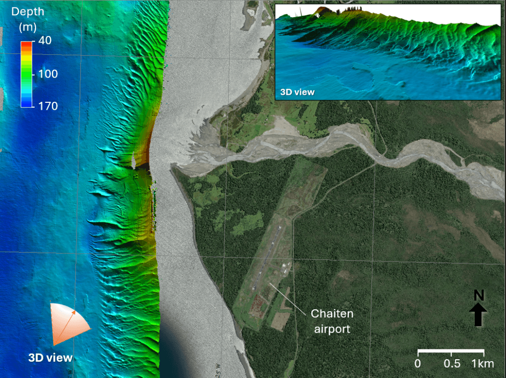
    The researchers mapped the seafloor near the volcano, finding massive dunes shaped by strong currents. Using a remotely operated vehicle, the team surveyed and sampled the seafloor, collecting sediments reaching back some 15,000 years. They also located ash from the 2008 eruption over 24 kilometers from the volcano. With their data, they hope to understand both how the recent eruption changed the marine environment as well as how older eruptions affected the area. (Image credits: volcano – USGS, dunes – Schmidt Ocean Institute; see also Schmidt Ocean Institute; via Ars Technica)

    Composite image showing the massive underwater dunes off the coast.
    Composite image showing the massive underwater dunes off the coast.

    P.S. – This Friday, January 24th from 12 to 1:30pm Eastern I’m moderating a panel discussion on the Traveling Gallery of Fluid Motion and how art and science can work together in public outreach. Register here to join. It’s free!

    Fediverse Reactions
  • Tracking Tonga’s Boom

    Tracking Tonga’s Boom

    When the Hunga Tonga-Hunga Ha’apai volcano erupted in January 2022, its effects were felt — and heard — thousands of kilometers away. A new study analyzes crowdsourced data (largely from Aotearoa New Zealand) to estimate the audible impact of the eruption. The researchers found that the volume, arrival time, and nature of the rolling rumble reported by survey takers correlated well with seismic measurements. But humans provided data that monitoring equipment couldn’t. For example, reports of shaking buildings and rattling windows let researchers estimate the shock wave‘s overpressure far from the volcano. The team suggests that acting quickly to collect human impressions of rare events like this one can add valuable data that’s otherwise overlooked. (Image credit: NASA; research credit: M. Clive et al.; via Gizmodo)

  • “Magic of the North”

    “Magic of the North”

    Fires glow above and below in this award-winning image from photographer Josh Beames. In the foreground, lava from an Icelandic eruption spurts into the air and seeps across the landscape as it slowly cools. Above, the northern aurora ripples through the night sky, marking the dance of high-energy particles streaming into our atmosphere, guided by the lines of our magnetic field. Throw in some billowing turbulent smoke, and it’s hard to get more fluid dynamical (or beautiful!) than this. (Image credit: J. Beames/NLPOTY; via Colossal)

  • A Seismic Warning for the Tongan Eruption

    A Seismic Warning for the Tongan Eruption

    In mid-January 2022, the Hunga Tonga-Hunga Ha’apai (HTHH) volcano had one of the most massive eruptions ever recorded, destroying an island, generating a tsunami, and blanketing Tonga in ash. Volcanologists are accustomed to monitoring nearby seismic equipment for signs of an imminent eruption, but researchers found that the HTHH eruption generated a surface-level seismic wave picked up by detectors 750 kilometers away about 15 minutes before the eruption began. They propose that the seismic wave occurred when the oceanic crust beneath the caldera fractured. That fracture could have allowed seawater and magma to mix above the volcano’s subsurface magma chamber, creating the explosive trigger for the eruption. Their finding suggests that real-time monitoring for these distant signals could provide valuable early warning of future eruptions. (Image credit: NASA Earth Observatory; research credit: T. Horiuchi et al.; via Gizmodo and AGU News)

    Fediverse Reactions
  • “Stomp-Rocket”: A New Type of Eruption

    “Stomp-Rocket”: A New Type of Eruption

    When Kilauea‘s caldera collapsed in 2018, it came with a sequence of 12 closely-timed eruptions that did not match either of the typical volcanic eruption types. Usually, eruptions are either magmatic — caused by rising magma — or phreatic — caused by groundwater flash-boiling into steam. The data from Kilauea matched neither type.

    Instead, scientists proposed a new model for eruption, based around a mechanism similar to the stomp-rockets that kids use. They suggested that, before the eruption, Kilauea’s magma reservoir contained a mixture of magma and a pocket of gas. When part of the magma reservoir collapsed, the falling rock compressed the gases in the chamber — much the way a child’s foot compresses the air reservoir of a stomp rocket — building up enough gas pressure to explosively launch debris and hot gas up to the surface.

    The team found that computer simulations of this new eruption model matched well with observations and measurements taken at Kilauea in 2018. Kilauea is one of the most closely monitored volcanoes in the world; although the team suspects this mechanism occurs during caldera collapse of other volcanoes, it’s unlikely they could have pieced together such a convincing case for an eruption anywhere else. (Image credit: O. Holm; research credit: J. Crozier et al.; via Physics World)

  • Featured Video Play Icon

    Icelandic Eruption

    When I started FYFD, volcano footage was far rarer. These days the affordability and durability of drones and action cameras — along with the relative accessibility of eruptions in places like Iceland and Hawaii — means we get to see volcanic flows in glorious high definition. This footage comes from the recent Icelandic eruption on the Reykjanes peninsula. Lava fountains line the four-kilometer lava vent seen here, and flows from the vent spread into a delta-like fan in the field below. I never get tired of staring at molten rock that flows like water. (Video and image credit: I. Finnbogason; via Colossal)

  • Underwater Volcanic Flows

    Underwater Volcanic Flows

    The Hunga Tonga–Hunga Ha’apai volcanic eruption in December 2021 was the most violent in 140 years, and we are still learning from its aftermath. A recent study focuses on the eruption’s incredible underwater flows, which damaged nearly 200 kilometers of underwater cables. From the cables’ locations and the time of service loss, the team calculated that gravity currents hit the cables at speeds as high as 122 kilometers per hour and with run-outs that lasted over 100 kilometers. These fast flows were triggered by material from the volcanic plume falling into the ocean, causing dense flows that swept down the submerged slopes of the volcano and seafloor.

    Illustration of volcanic plume material falling into the ocean and triggering underwater flows.
    Illustration of volcanic plume material falling into the ocean and triggering underwater flows.

    Previously, a landslide broke underwater telegraph cables off Newfoundland and a coastal construction accident severed a cable in the Mediterranean. But neither of those incidents revealed the same level of speed, distance, and destructive capacity as the Tongan eruption. It seems that these underwater gravity currents pose an ongoing threat to submerged infrastructure. As more cables are laid in volcanically-active regions of the Pacific, we will need more extensive mapping and monitoring of the seafloor to protect against future disruptions. (Image credit: eruption – Tonga Geological Services, illustration – APS/C. Cain; research credit: M. Clare et al.; via APS Physics)

  • Featured Video Play Icon

    Tongan Eruption

    In January 2022, the Hunga Tonga-Hunga Ha’apai volcano erupted spectacularly, sending waves around the world through the air, water, and ground. In many ways, it was unlike any eruption scientists have observed, though they think it bears similarities to the 1883 eruption at Krakatoa. This video summarizes some of the research to come out of the eruption, looking at how waves propagated, what aerosols the volcano pushed high into the atmosphere, and what the long-term effects of the eruption may be. (Video credit: Science)

  • Landslide-Triggered Tsunamis

    Landslide-Triggered Tsunamis

    After the 2018 Anak Krakatoa eruption, a tsunami that ricocheted through the surrounding waters, killing hundreds on nearby islands. The source of that tsunami was a small landslide. Once the air cleared and researchers could assess how much material slid into the ocean, they were shocked that such a small volume created so much destruction.

    Now new efforts are revealing the linkage between landslides and the waves they make. Researchers released glass beads into a tank of water, observing the waves that form as the beads run out. Depending on the relative initial height of the beads compared to the water depth, they observed three different kinds of waves. Not only that, they were able to connect the granular mechanics of the landslide to the hydrodynamic formation of waves, allowing predictions of the waves that will form for a given landslide.

    Currently, the predictive model isn’t sophisticated enough to handle a geometry as complex as that of the Anak Krakatoa landslide, but it’s an important step toward understanding — and potentially mitigating the damage of — future oceanside landslides. (Image and research credit: W. Sarlin et al.; via APS Physics; submitted by Kam-Yung Soh)

  • Submarine Eruptions

    Submarine Eruptions

    The green-blue plume on the left of this satellite image is an eruption from Kavachi, an underwater volcano in the Solomon Islands. Kavachi’s crest is currently estimated to lie 20 meters below the surface, with its base at a depth of 1.2 kilometers. Eruptions are quite common at the volcano, but that doesn’t stop wildlife — like hammerhead sharks! — from making the crater their home. Over the last century, Kavachi’s eruptions have repeatedly formed small islands at the surface, but they were quickly eroded away by wave action. (Image credit: J. Stevens/NASA/USGS; via NASA Earth Observatory)